'As far back as 1939, archaeologists could show that Australia was criss-crossed by Aboriginal trade routes (see map, above, for more detail on these routes). For Isabel McBryde – ‘the mother of Australian archaeology’ – these Aboriginal trade networks were ‘among the world’s most extensive systems of human communication recorded in hunter-gatherer societies’...
'The extent of cultural exchange between Aboriginal groups is indicated by the widespread Panaramitee rock art style – also known as ‘track and circle’ – which is found across mainland Australia and Tasmania'...
'In 1974, the archaeologist Lesley Maynard studied engravings in Laura in Queensland, Mount Cameron West in Tasmania, and Ingaladdi in the Northern Territory, each of which she believed to be part of the Panaramitee style. The Tasmanian find was particularly important, indicating that the style developed before the creation of the Bass Strait by rising seas at the end of the Ice Age.
'This led her to develop a chronology of Australian rock art. The first was ancient ‘deep cave art’, produced in the last Ice Age; then the homogenous and widely distributed forms of the Panaramitee, also dating to the Pleistocene (Ice Age); and finally the regionally diverse styles of the Holocene (post-Ice Age), both ‘simple figurative styles’, and ‘complex figurative styles’, including the striking Wandjina of the Kimberley, and the intricate X-ray art found in Arnhem Land and Kakadu.'
'Makassar people from the region of Sulawesi in Indonesia began visiting the coast of northern Australia sometime around the middle of the 18th century, first in the Kimberley region, and some decades later in Arnhem Land. They were men who collected and processed trepang (also known as sea cucumber), a marine invertebrate prized for its culinary value generally and for its supposed medicinal properties in Chinese markets. The term Makassan (or Macassan) is generally used to apply to all the trepangers who came to Australia.' - https://en.wikipedia.org/wiki/Makassan_contact_with_Australia
Since the early 20th century archaeologists could show that Australia was criss-crossed by Aboriginal trade routes. For Isabel McBryde – ‘the mother of Australian archaeology’ – these Aboriginal trade networks were ‘among the world’s most extensive systems of human communication recorded in 'hunter-gatherer'* societies’.
Goods and people travelled vast distances: the Dieri people, east of Lake Eyre, South Australia, visited places at least 800 kilometres apart; while shell from Papua New Guinea reached western New South Wales (Gammage, 149).
Every individual was touched by trade: as archaeologist John Mulvaney has written,
‘it was possible for a man who had bought pituri from the Mulligan River and ochre from Parachilna to own a Cloncurry axe, a Boulia boomerang and wear shell pendants from Carpentaria and Kimberley‘ (Griffiths, 47-48).
Trade had a cultural and social importance, as Mowaljarlai and Malnic (1993) write:
‘The lines are the way the history stories travelled along the trade routes. They are all interconnected. It’s the pattern of the sharing system.’ - [See Map Link Below]
Some goods had a social value that meant they were traded particularly widely. Pearl shells from the Kimberley coast have been believed to have travelled at least 800 kilometres away from their point of origin; with some claiming that they reached as far as the mallee, in western Victoria and eastern South Australia. Some pearl shells were as wide as a small plate, engraved with patterns and worn as a pendant by powerful men.
Stone axes also spread over vast distances. At Calingorady Creek (Moore Creek), near Tamworth, New South Wales, an outcrop of greywacke running along the crest of a saddleback ridge was mined prolifically for over 100 metres. In the 1960s, McBryde used petrological analysis – which had previously been used to show that the bluestone used in building England’s Stonehenge had come from Pembrokeshire, Wales – to examine 517 stone axes that had been scattered across New South Wales. They found that rock from the quarry near Tamworth had been carried as far as Cobar, Bourke, Wilcannia and other parts of western New South Wales – a journey equal to that between Belgium and the south of Spain (Blainey, 191-192).
Ochre was another commodity which was traded widely. Red ochre was particularly important to First Nations peoples across Australia: it was used to adorn the body during ceremonies, decorate wooden implements, and in rock art. The ochre trade is particularly ancient: Mungo Man, the 40, 000 year old ritual burial found in the Willandra Lakes area of Western New South Wales, the traditional meeting place of the Muthi Muthi, Nyiampaar and Barkinji Aboriginal tribes, was covered in over two kilograms of red ochre. The ochre had been brought over 200 kilometres to the burial site (Griffiths, 131).
The first material to be mined in the Flinders Ranges, South Australia, was not copper or gold but red ochre. Ochre from a quarry east of Parachilna township, known as Bookatoo, was celebrated among the Dieri people of central Australia. It was regarded as being of an exceptionally high quality, and held a spiritual importance, believed to be the blood of a sacred emu. The Dieri would send armed bands of 70-80 men 500 kilometres to the south to barter with the traditional owners of the mine, the Adnyamathanha people – even though there were plenty of more accessible ochre mines, such as the Ochre Cliffs near Lyndhurst on the Strzelecki Track.
It is also likely that the Dieri people used their access to the prized ochre to trade for pituri, a psychoactive drug made from the leaves of duboisia hopwoodii, used as both a painkiller and stimulant. The most prized variety of pituri comes from near Bedourie in western Queensland, which was traded north to the Gulf of Carpentaria and south as far as Kurdnatta (Port Augusta South Australia). It is said that pituri provided the one solace for Burke and Wills, slowly dying in remote Central Australia in 1861 (Flood, 202).
The act of trade had a cultural importance; taking on ritual and ceremonial aspects. It shaped the way that landscapes were understood. Particular localities became associated with particular manufactured goods, as different groups made objects with skill that was admired elsewhere. This specialisation was the basis of trade. So, for instance, groups living near Mparntwe (Alice Springs region) were particularly admired for skill in making wooden bowls used for liquids. Specialisation was a source of identity, often expressed through local mythologies (Blainey, 194).
The extensive travel that trade required meant that Aboriginal people had a vast knowledge of the world in which they lived, far beyond their direct locality. They used knowledge of the stars to guide them on long journeys; and had understandings of places that they did not have direct experience of. Early West Australian settler George Moore observed that ‘the natives are all aware that [Australia] is an island’. In 1840, men near Fowler’s Bay, South Australia, correctly assured Edward John Eyre that there was no inland sea; while Sturt recalled that Toonda, his guide in 1844, was able to accurately draw a plan of the Murray-Darling river system.
Aboriginal people studied the world that surrounded them, exchanging long-distance visits to learn of far-away lands and skills. Songs and ceremonies, holding practical knowledge needed for survival and navigation of the land, travelled thousands of kilometres in a short period along what is known as Songlines.
Anthropologists were astounded, for example, when Aboriginal women in Kurdnatta (Port Augusta), South Australia, accurately provided details of places in a song series describing Mparntwe (Alice Springs region), 1200km away. They were able to trace the trading of the ceremony, songs, stories, dances and art back to Mparntwe via the outback South Australian town of Utnadata (Oodnadatta).
This trading of songs can be thought of as a trading of intellectual property to assist travelling. Aboriginal people travelled a lot. They renewed and created relationships and socialised at small ceremonies and huge gatherings. They travelled for seasonal harvests on land, in rivers or at sea, either seeking or avoiding dominant weather events. If you knew the songs, you held knowledge of the land to aid navigation as well as find water and food resources.
Trade also necessitated linguistic dexterity, as Walter Roth, the ‘Aboriginal protector’ of Northern Queensland, recalls:
Picked men may be sent to a distant tribe just for the sake of learning [a dance] … It may thus come to pass, and almost invariably does, that a tribe will learn and sing by rote whole corrobborees [sic] in a language absolutely remote from its own.
Though there was no common language across the continent, there was extensive contact between different language groups. Children frequently had parents who spoke different languages. People spoke up to three or four languages, and some could understand several more; making Aboriginal Australians among the world’s most multilingual people. Such multilingualism is still common today, with people in Arnhem Land frequently speaking English as a third (or thirteenth!) language.
Dialect chains enabled long-distance communication. For example, Group A was able to understand Group B, who understood Group C, but Group A might not have been able to understand Group C (Flood, 173). In Central Queensland and the Western Desert, these chains extended over 3000 kilometres.
THE PANARAMITEE ROCK ART TRADITION: MARKINGS IN THE LAND
The extent of cultural exchange between Aboriginal groups is indicated by the widespread Panaramitee rock art style – also known as ‘track and circle’ – which is found across mainland Australia and Tasmania.
The style was 'discovered' by Bob Edwards, an amateur field photographer on a survey of north-east South Australia with his mentor, Charles Mountford. One of their starting points was the series of engravings found at Panaramitee Station.
Moving from station to station, they found over a thousand similar pieces of art, depicting animal tracks and circles, and less frequently crescents, human footprints, radiating lines, and other nonfigurative designs. These same motifs appeared in a number of sites.
Early European explorers had believed the engravings to be fossil footprints, or the result of algae and lichens eating into rock. But it was clear that they were human markings, formed by pecking with a stone hammer into the rock, which were then covered by ‘desert varnish’, a shiny, rust-coloured accretion that builds up over a long period of time. Mountford believed that the varnish was evidence that the carvings were extremely old, confirmed by his interviews with Aboriginal elders, who claimed that the engravings ‘had always been there.’
As Edwards and Mountford ended their survey, the rains hit, filling rockholes and causing creeks to flow. This stroke of good luck revealed to them another continuity of the engravings: each was next to a waterhole, or other form of supply.
Over the following three years, Edwards collected instances of this style across South Australia and the arid centre of Australia, virtually all associated with water sources and arid camp sites. He had uncovered what archaeologists call a ‘stylistic unit’, the artistic signature of an ancient, widespread cultural tradition. The consistency of the drawings led him to believe that these motifs predated ‘the time when tribal boundaries became rigid and separate cultural entities developed.’
In 1966, as part of a team of researchers led by John Mulvaney, Edwards uncovered tracks and grooves resembling the Panaramitee engravings, at a site west of Katherine, in the Northern Territory. They were able to date the engravings at 5000-7000 years old, the first such dating of rock art in Australian history, proving Edwards’ argument that the style was ancient.
In 1974, the archaeologist Lesley Maynard studied engravings in Laura in Queensland, Mount Cameron West in Tasmania, and Ingaladdi in the Northern Territory, each of which she believed to be part of the Panaramitee style. The Tasmanian find was particularly important, indicating that the style developed before the creation of the Bass Strait by rising seas at the end of the Ice Age.
This led her to develop a chronology of Australian rock art. The first was ancient ‘deep cave art’, produced in the last Ice Age; then the homogenous and widely distributed forms of the Panaramitee, also dating to the Pleistocene (Ice Age); and finally the regionally diverse styles of the Holocene (post-Ice Age), both ‘simple figurative styles’, and ‘complex figurative styles’, including the striking Wandjina of the Kimberley, and the intricate X-ray art found in Arnhem Land and Kakadu.
Maynard’s chronology has since been challenged by other archaeologists, including Andrée Rosenfeld, who has argued for greater cultural difference between North Queensland styles and those found in the ‘red centre’. Others have challenged the antiquity of Panaramitee style, suggesting that many of the tracks do not actually date back to the Pleistocene. Many of the artworks found in the central deserts of Australia are of much more recent origin, indicating a continuation of the style into recent years across a large part of Australia (Griffiths, 174-199).
TRADE IN SOUTH-EAST AUSTRALIA:
The trade of Aboriginal peoples in south-east Australia (southern New South Wales and Victoria) has been extensively studied by Isabel McBryde.
In particular, greenstone axes produced at the Mount William Stone Hatchet Quarry (known as Wil-im-ee Moor-ring), on the outskirts of Melbourne, were revealed by McBryde to have travelled over 1000 kilometres across southern Australia. The quarry today, listed as a National Heritage Place, bears the scars of thousands of years of mining by the traditional owners, the Wurundjeri. Deep pits were dug to reach unweathered stone; and the surface of boulders were heated to break away pieces of rock. The heads were then shaped using a large boulder as an anvil, which were then shaped further by their new owners.
Though the whole tribe had an interest in the place, it was under the special custodianship of one man (in the 19th century, a man named Billibellary), who had inherited this from his father, and traded stone for weapons, rugs and ornaments. In one instance, a visitor exchanged a possum-skin rug for three pieces of the stone (McBryde, 148). It seems to have supported a sedentary population: one settler described thirteen ‘warm and well constructed huts’ near Mount William (Gammage, 300).
Stone from the quarry reached the numerous groups of the Murray River, as far away as Yelta (near Mildura). Early settler Isaac Batey was told in 1862 by an Aboriginal stockman from the Lachlan River, New South Wales, that stone for hatchet heads came ‘from a hill down in the Melbourne country’ (McBryde, 133), while the stone also reached Guichen Bay, near Mount Gambier, South Australia.
In turn, the people of the Murray produced goods from the roots of kumpung river grass. Twine was made by twisting fibre, which was used for fishing line; bags, belts and headbands; for binding axe heads; and for ritual purposes. It was also knotted into nets, used to fish and catch emu, ducks, and small animals. Each group needed around thirty-five kilometres of raw twine to have a set of nets, which meant that twelve kilometres of twine had to be manufactured each year. In total, the process of creating a net took around a year of 35-hour weeks. The work of preparing twine and smaller nets was done primarily by women, while men worked on the larger nets. Much like in pre-industrial England, work was cooperative and social, as people sat around, gossiped, and told stories while producing objects.
Great trading meetings were held on the Murray River. These festivities were often tied to particular food harvests, such as the collection of taarp (lerp), a carbohydrate secreted on eucalypt leaves by plant-eating insects, prized for its sugary taste.
The eel harvest of the Budj Bim Cultural Landscape – a sophisticated aquaculture system that is believed to have supported a sedentary population – was another major festivity, which attracted people from as far away as New South Wales and South Australia to feast on smoked eels caught in the traps. The Brewarrina Fish Traps of northern New South Wales were also host to one of Eastern Australia’s great festivities, with huge numbers of people coming to partake of the harvest, with fish complimented by flour-based breads.
PATTERNS OF EXCHANGE IN ARNHEM LAND:
At the other end of Australia, the trading and exchange patterns of the people of Arnhem Land have also been extensively studied. Thanks to challenging tropical conditions and the fierce resistance of the local Yolngu people, Arnhem Land was never conquered or systematically settled by British colonisation. For the British, its history is a series of failed military, pastoral and mining settlements. As a result, traditional Yolngu life patterns have remained strong to this day.
In the 1930s, the anthropologist Donald Thompson studied the trading patterns of the Yolngu people extensively. Thompson found that every individual in Arnhem Land was a part of a ‘great ceremonial exchange cycle’. A man on the Lower Glyde River, for example, would have received black pounding stones from the east; possum fur, dillybags and spearheads from the south-east; boomerangs, hooked spears and ceremonial belts from the southwest; heavy fighting-clubs from the north-west; and foreign goods (traded by Macassan sailors) from the coastal north-east, calico, blankets, tobacco, knives and glass, much of which he traded away in further exchanges.
FISHING
This exchange cycle was at the heart of Arnhem Land culture: each individual was under a social obligation to send gifts to partners in remote areas. The act of giving gave esteem, while slowness and a lack of generosity in giving earned disapproval, even social ostracism.
Unlike trade elsewhere in pre-settlement Australia (with the exception of the trade between Cape York, the Torres Strait Islands, and Papua New Guinea), Arnhem Land formed part of a truly international network of exchange. For centuries fishermen and voyagers from Makassar, a city on Indonesia’s Sulawesi island, searched the shores of Arnhem Land in search of trepang, a sea cucumber prized as a delicacy in China.
Anthropologist Campbell Macknight suggested that the trade began between 1650 and 1750, while later scholars such as Darrell Lewis and Anne Clarke have argued that the Macassans started visiting much earlier, around 1000 years ago. The trade only came to an end in 1907, outlawed by the brand-new Australian government.
While on the shores of Arnhem Land, the Macassans grew rice, built stone hearths, and traded with the local Yolngu community, exchanging tobacco, pipes, beads, belts, cloth, iron knives and axeheads and strong dugout canoes, known as lippa-lippa, for the right to fish on Australian waters and employ local labour. They introduced new technologies, such as the dug-out canoe, and inspired a shift in diet to one including more seafood. Macassan words entered the local languages, and some Yolngu people even spent time in the city of Makassar.
The Makassars were integrated into the global trade network, passing goods on to China and using Dutch coins (thanks to Dutch colonisation in Indonesia). The extent of global connection to Arnhem Land is displayed by the mystery of a 12th century African coin found by a serviceman during World War Two.
Macassan goods travelled widely in Australia, even down to the ‘red centre’: botanist Christopher Giles found in a rainmaker’s bag by the Finke River, in central Australia, ‘a curious examples of extremes meeting’, pearl shells obtained from ‘the Malays’ and a boy’s marble from Adelaide.
THE BODY OF AUSTRALIA: A CONNECTED CONTINENT:
Evidence of the trade routes in Aboriginal Australia indicates that Australia was a network of peoples ‘economically integrated’ by the Dreaming. Ngarinyin lawnan David Mowaljarlai, the late elder of the Kimberley, Western Australia, detailed the interconnectedness of Aboriginal people in his map Bandaiyan, Corpus Australis (The Body of Australia) - [See Map Link below].
On his map the whole continent and its islands are joined in a single grid system of social and spiritual connections. The diamonds within the pattern are communities of Aboriginals and the lines connecting them the ancient trade routes and Dreaming pathways that Mowaljarlai calls ‘landstories’. At the nodes connecting the lines is concentrated knowledge – sites of significance or ‘story places’ in which knowledge is embedded. Corpus Australis represents the country as connected through these nodes in the sharing of resources and technology over millennia.
The map of Australia is remapped by Mowaljarlai as a map of the human body, with the line from the Gulf of Caprentariria to the Great Australian Bight the spinal column on which the body is constructed. Cape York and Anhrem Lands constitutes the lungs, Uluru the bellybutton, the Great Australian Bight the public sections, and the southern offshore islands the feet.
For Aboriginal people, society, the environment, and the individual person are not separate from each other. Rather they are united in what the author Mudrooroo describes as “the unity of the people with natural and all living creatures and life forms”. Life and land are intimately connected in a vast network interwoven across vast landscapes.
Many of the most successful exploits of settlers and explorers was thanks to their making use of older Aboriginal trade routes. John McDouall Stuart, the first European to cross the Australian continent, followed an Aboriginal route that led traders from spring to spring in the harsh South Australian outback, linking Cape York and the Kimberley to the southern coast. This route was used in the 1870s to establish the Australian Overland Telegraph Line, connecting Port Augusta to Darwin, with the help of camels and camelmen from the Middle East and Asia.
The route was later used by camel trains led by ‘Afghan’ cameleers to haul goods into central Australia and formed the base of the Great Northern Railway, known as the Ghan, which closed in 1980.
Similarly, the cattle thief and bushman, Harry Reardon, was able to successfully transport 1200 head of stolen cattle from Bowen Downs Station, 130 kilometres north of Longreach, 1000 kilometres south to Hill Hill Station, South Australia, thanks to his communication with Aboriginal people, which allowed him to navigate the desert successfully. The route he established from Lyndhurst to Innamincka was one long traversed by Aboriginal traders, who transported red ochre from the Ochre Cliffs near Lyndhurst north to the Gulf of Carpentaria and south to the Southern Ocean, today known as the Strzelecki Track.
The town of Halls Creek, Western Australia, was an important place of exchange for the traditional owners, the Jaru and Kija people, thanks to its location on the trading routes stretching from the centre of Australia to the Kimberley coast. Even in the cities, many of today’s major landmark have long been ceremonial gathering places for Aboriginal people, including the Melbourne Cricket Ground and King’s Park, Perth.
Map of trade routes and storylines linking Aboriginal nations across Australia named 'Bandaya', by David Mowaljarlai (1928 - 1997), senior lawman of the Ngarinyin people in the West Kimberley Western Australia: https://bit.ly/3HjAwXh
Map showing the extent of Map showing the extent of Panaramitee style carvings. Image by Ellen Tiley. Image by Ellen Tiley. https://bit.ly/3FCHMxa
Civilised people (i.e. from the culture of towns and cities) came to Australia, America etc and saw wilderness. They didn't see a managed environment; but it was there.
One aspect of aboriginal land management was and is 'cool burning' - the periodic deliberate starting of grass fires to clear away flammable debris and so prevent the kind of mega-blazes we saw recently in Australia, which killed perhaps 3 billion animals.
This has also been an ancient practice among Native Americans:
Similarly, in both countries there are sacred areas, some of which would seem to the ignorant eye to be simply wild places, missing the point that they are carefully kept that way:
There is the archaeology of relics, but there is also the archaeology of the human mind and its cultures. How old, for example, are the stories of the Dream Time?
As Yeats said: 'I have spread my dreams under your feet; Tread softly because you tread on my dreams.'
Having said that, an archaeological dig in the Torres Strait has recently found concrete evidence of cultivation of bananas 2,000 years ago:
'Lead researcher Robert Williams said... the Torres Strait had been historically viewed as a "separating line" between Indigenous groups in New Guinea - now part of Indonesia and Papua New Guinea - who practiced agriculture, and those in Australia who were labelled "hunter gatherers". 'But the findings show that the strait was "more of a bridge or a filter" for horticultural practices across both regions.'
In Rapa Nui aka Easter Island, archaeologists have uncovered the buried torsos of the ancient stone 'moai', revealing carvings (petroglyphs) representing Polynesian canoes:
It's theorised that the moai were funerary headstones for members of different tribes on the island, as there are human remains found around these statues.
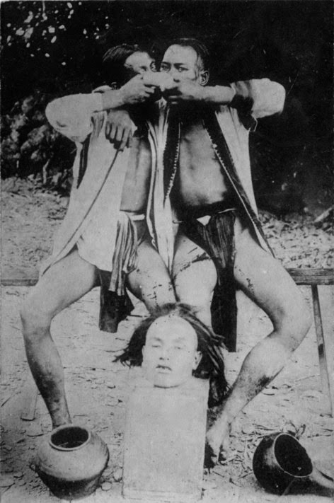
This photograph appeared on the Facebook page 'Philippine and world's indigenous tribes news and history' (20 March 2016) and at first glance the hunters celebrating behind the surprised and disappointed head might seem to be fist-bumping; instead it looks as though they are sharing something, or disguising their faces.
The accompanying text reads:
"HEADHUNTERS OF TAIWAN Between 1903 and 1908 there were seventy advancements made to the guard lines by the Japanese, but indigenous men in search of heads often came over or under the barrier at nightfall to lay waiting in ambush for unsuspecting victims. Headhunting, the primary ritual component of the Atayal, Paiwan, Saiset, and other groups, not only served to maintain the prosperity of society by ensuring agricultural and community fertility through the propitiation of the deities and ancestors, it also ensured that a man would meet with success in finding a wife while at the same time guaranteeing his safe passage to the afterlife. Thus, the custom was considered indispensable to life and existence itself. Among the Atayal, success met on the headhunt was deliberately marked upon the chins of warriors with tattoos. And those headhunters who acquired more than five heads using old weapons, like a curved machete-like knife, might also have their chests tattooed or the backs of their hands. Among the Paiwan, it was believed that the spirits of ancestors dwelled in these beheading knives, which were held in the possession of the tribe for several generations. However, the Paiwan were not necessarily tattooed after having taken a head; instead, the successful warrior was also denoted by the wearing of a certain kind of cap which was made by women of the tribe. More generally, tattooing could also be administered to the foreheads of unmarried Atayal boys and girls in their teens. Apart from the tattooed foreheads of women, only those who were skillful in weaving could tattoo their cheeks and other parts of their bodies. Besides the beautiful cloths they wove on the loom, Atayal women also manufactured net bags that headhunting husbands used to carry severed human heads. Next to his beheading knife, these bags were his most treasured possession. It is not surprising, then, that the Atayal believed that only those women who were proficient in weaving (hence tattooed), and those men who were successful headhunters (also tattooed) could pass safely into the afterlife."
- but is taken from a longer - and interesting - post here that does not include the image above:
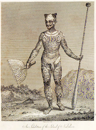
'The German explorer and ethnologist Karl von den Steinen, who visited the isles in 1891, listed over one-hundred and seventy individually named tattooing motifs which is remarkable since the tradition was "banned" by French officials approximately fifty years before that time.'
- http://www.vanishingtattoo.com/tattoo_museum/marquesas_tattoos.html
'After a detailed DNA analysis of the genomes of more than 800 Polynesians and Native Americans, both modern and prehistoric, researchers have found evidence of contact between the two groups as far back as 1200 CE...
"Our analyses suggest strongly that a single contact event occurred in eastern Polynesia, before the settlement of Rapa Nui, between Polynesian individuals and a Native American group most closely related to the indigenous inhabitants of present-day Colombia," the researchers explain in their paper.
Anuta tempts the philosopher and moralist. Its 300 Polynesian people live on the smallest inhabited island in the South Pacific and sustain themselves by carefully harvesting their natural resources. Fragile, precious, beautiful life in utter isolation - a metaphor for planet Earth in a universe where we may still turn out to be alone.
The BBC sent ex-Royal Marine Bruce Parry there in 2007; he said afterwards, "If I had to pick one tribe to go back and live with permanently — and I hate doing this, it’s not a contest — it would be the people of Anuta [...] It’s got white beaches, blue seas, good food and gentle, friendly people who have a wonderful philosophy of sharing." The communal ethic is calleed "aropa" in their language.
BBC reporter Huw Cordey was part of the 2009 visit and made a radio programme for the Nature series, called "Anuta - An Island Governed By Love". He found that even in Anuta there are discontents, like anywhere else.
Yet we're still haunted by the myth of the happy land. As the poet Elizabeth Jennings says, "Sickness for Eden was so strong."
Our ramble begins with an internet writer's reference to an Australian comedy book from the Seventies, The Outcasts Of Foolgarah. Surfing the reviews, I came across a Depression-era larrikin Oz classic, Here's Luck, by journo and rake Lennie Lower, which is now making us laugh.
But Outcasts, by Frank Hardy, was far from the author's most significant work. His most notorious was one that got him in court for criminal libel - the last case of its kind in Victoria; but that's not where this journey leads us. The experiences of the Depression that gave Lower his comic material had radicalised Hardy, as they did so many others, prompting him to join the Communist Party and use his talents to fight the Establishment.
We have since learned what Communism did; but the instincts that it exploited - compassion for the poor, and vicarious indignation - are valid. In our secular age, they inform ecological panic and adolescent self-loathing, an opportunity for ostentatious do-gooders to secure bossy, well-upholstered sinecures for themselves.
In Australia, they take us to the aboriginals.
Twenty thousand years before Neanderthals recolonised an unpeopled Ice Age Britain, forty thousand before modern man supplanted them in Europe, even longer before humans saw the Americas, the first Australians came to their island continent. Early agriculture? The cities of China and Mesopotamia, Egypt and Mohenjo Daro, the stones of Wiltshire and Giza? Last week's news.
For them, time had no meaning, as is so with all of us, our past always fading into dream, driving us to build, write, record images; futile attempts to preserve our intangible selves in something that endures forever, though nothing will.
Where are their monuments? In their minds, and in their tongues. In their myths of creation and arrival, in the songman's store of rhymes that give life-saving directions for nomads in a pitiless land; an inconceivably long heirloom of songs, some maybe stretching back to the birth of language itself. Old to young, old to young, the chain continued, handing on words and skills that gave them their law and culture; the policeman and warrior, the getter of food and drink, the builder of shelters contained in their skins and carried within their hands and brains wherever they went.
Until the last link broke.
Dispossession, displacement, disrespect; opium via the Oriental trading in Port Darwin; alcohol everywhere, ruining the young as it did their counterparts in America, where sometimes crazy-drunk First Nation kids hang out of cars as they tear around settlement lands which they cannot sell or mortgage.
Instead of the remorseless pressure of daily survival, jobs: money, enough to get by and for some, to dream the modern dreams of easy intoxication. And since the young stopped listening to the old, the elders (some, at least) shut their lips. One by one, the guiding stars of the aboriginal are winking out of existence, taking their knowledge with them.
Materially, a little is done to compensate material wrongs, some in response to action by the victims themselves. Following a walkout in 1966 by mistreated Gurindji aboriginal workers at the vast Wave Hill cattle station, a small portion of their traditional lands were eventually restored to them, and the law has begun to address past injustices. Frank Hardy helped to publicise the issues in his book The Unlucky Australians, and a TV documentary followed.
What can make up for the vast, invisible vandalism of an ancient way of life? Like all humanity, the original Australians have always known war and crime, but what they carried in them was no less precious and far older than the historical relics over which we wonder and grieve in museums.
Still, many times older is the history of humanoids written into all our genes, itself dwarfed by the general relay of life that began billions of years ago. It is fleeting life that endures.
Bill Harney on a love triangle in 1940s Arnhem Land:
______________________
I have found that native tradition, with its prohibitions and fixed customs, really eliminates those things we know as sin and morals...
Some people tried to break down this code, but it always brought trouble in its wake. I well remember an aboriginal couple who were married 'Christian way in church'. The woman was not aware that the union was a fixed one - not as in the tribe, where the people can become divorced by mutual consent.
The marriage irked her so much that she decided to break it up and take to herself another man of the tribe. Her method was simple and ingenious.
She became the friend of another native man I knew and, unknown to him, used him as a means of arousing her husband to such a jealous madness that he crept upon the man, who he thought was his wife's lover, and killed him with a spear.
I found it all out too late, and even then I could not stop the self-satisfied smile on the real killer's face, as her husband went to jail whilst she returned to her true lover.
_______________________
"Life Among The Aborigines" by W. E. Harney, Robert Hale Limited (1957) - pp. 15, 31-32
Imposing a way of life can have terrible consequences. This story has a universal feel to it, about the dangers of trying to dam natural drives:
I well remember an aboriginal couple who were married "Christian way in church". The woman was not aware that the union was a fixed one - not as in the tribe, where the people can become divorced by mutual consent.
The marriage irked her so much that she decided to break it up and take to herself another man of the tribe. Her method was simple and ingenious.
She became the friend of another native man I knew and, unknown to him, used him as a means of arousing her husband to such a jealous madness that he crept upon the man, who he thought was his wife's lover, and killed him with a spear.
I found it all out too late, and even then I could not stop the self-satisfied smile on the real killer's face, as her husband went to jail whilst she returned to her true lover. From "Life among the aborigines" by W E Harney, Robert Hale, 1957 (pp. 31-32)
The next time you’re driving down a country road in outback Australia, consider there’s a good chance that very route was originally mapped out by Aboriginal people perhaps thousands of years before Europeans came to Australia.
And like today, they turned to the skies to aid their navigation. Except instead of using a GPS network, they used the stars above to help guide their travels.
Aboriginal people have rich astronomical traditions, but we know relatively little about their navigational abilities.
We do know that there was a very well established and extensive network of trade routes in operation before 1788. These were used by Aboriginal people for trading in goods and stories, and the trade routes covered vast distances across the Australian continent.
Star maps
I was researching the astronomical knowledge of the Euahlayi and Kamilaroi Aboriginal peoples of northwest New South Wales in 2013 when I became aware of “star maps” as a means of teaching navigation outside of one’s own local country.
My teacher of this knowledge was Ghillar Michael Anderson, a Euahlayi Culture Man from Goodooga, near the Queensland border. This is where the western plains and the star-filled night sky meet in a seamless and profound display.
Ghillar Michael Anderson and a possible waypoint.Author provided
One night, sitting under those stars in Goodooga, Michael pointed out a pattern of stars to the southeast, and said that they were used to teach Euahlayi travellers how to navigate outside their own country during the summer travel season.
As an astronomer, I immediately realised that those stars were not in the direction of travel that Michael was describing. And anyway, they wouldn’t be visible in the summer, let alone during the day when people would have been travelling.
Michael said that they weren’t used as a map as such, but were used as a memory aid. And in the Aboriginal manner of teaching, he asked me to research this and come back to see if “I had gotten it”.
I did some research, and looked at a route from Goodooga to the Bunya Mountains northwest of Brisbane, where an Aboriginal Bunya nut festival was held every three years until disrupted by European invasion.
It turned out the pattern of stars showed the “waypoints” on the route. These waypoints were usually waterholes or turning places on the landscape. These waypoints were used in a very similar way to navigating with a GPS, where waypoints are also used as stopping or turning points.
Star map route to the Bunya Mountains.Starry Night Education
Stars to songlines
Further discussion revealed the reasons and methods of this technique. In the winter camp, when the summer travel was being planned in August or September, a person who had travelled the intended route was tasked with teaching others, who had not made this journey, how to navigate to the intended destination.
The pattern of stars (the “star map”) was used as a memory aid in teaching the route and the waypoints to the destination. After more research I asked Michael if the method of teaching and memorising was by song, as I was aware that songs are known to be an effective way of memorising a sequence in the oral transmission of knowledge.
Michael said, “you got it!”, and I then understood that the very process of creating, then teaching, such a route resulted in what is known as a songline. A songline is a story that travels over the landscape, which is then imprinted with the song (Aboriginal people will say that the landscape imprints the song).
I then learned that there were many routes/songlines from Goodooga to destinations as far as 700km away, which might end up in a ceremonial place, or possibly a trade “fair”.
One such route to Quilpie, in Queensland, led to a ceremonial place where Arrernte people from north of Alice Springs met the Euahlayi for joint ceremonies.
Their route of travel was more than 1,500km, crossing the Simpson Desert in summer, and I was told that they would have their own star map/songline for learning that route. The implication of this is that the use of star maps for teaching travel may have been common across Australia.
Star map route to the Carnarvon Gorge.Starry Night Education
Parallels
Another surprising result of this knowledge came about when I was looking at the star map routes from Goodooga to the Bunya Mountains and Carnarvon Gorge in Queensland. When the star map routes were overlaid over the modern road map, there was a significant overlap with major roads in use today.
After some reflection, the reason for this became clear. The first explorers in this region, such as Thomas Mitchell, who explored here in 1845-1846, used Aboriginal people as guides and interpreters, who were likely given directions by local Aborigines.
Carnarvon Gorge and Bunya Mts star maps overlaid on road map.Google Earth
These directions would no doubt reflect the easiest routes to traverse, and these were probably routes already established as songlines. Drovers and settlers coming into the region would have used the same routes, and eventually these became tracks and finally highways.
In a sense, the Aboriginal people of Australia had a big part in the layout of the modern Australian road network. And in some cases, such as the Kamilaroi Highway running from the Hunter Valley to Bourke in NSW, this has been recognised in the name.
Robert will be on hand for an Author Q&A between 3 and 4pm AEST on Thursday, April 7, 2016. Post your questions in the comments section OF THE ORIGINAL ARTICLE - link given below. Robert S. Fuller, PhD Student Indigenous Cultural Astronomy, UNSW Australia
This article was originally published on The Conversation. Read the original article.
"Australia rock art - Mimis and Kangaroo, rock art, Oenpelli, Arnhem Land, Australia. Older painting before 7,000 BCE, Kangaroo probably post-contact. (Sayre, 2010, p. 975)" - https://uk.pinterest.com/pin/521502831831829461/
Bill Harney, looking at cave art in Arnhem Land in the 1940s:
Kangaroos, bandicoots, fish, reptiles - all are drawn nice and fat because he desires them that way.
Many of the paintings have been drawn as though seen through an X-ray, and beholding them we are amazed at the line details of the creature's internal organs. I questioned one of the artists who was working on a bark painting, and he described things to me.
"This," he explained, as he pointed out an object amidst the intestines, "is the fat." Then, with emphasis, "Proper fat this one." "That there," again on the anatomy, "is the heart. This red thing is the liver and the fine white lines are the backbone."
Each part was pointed out and it was correctly in place. Nothing strange about this, because these people had been cutting up and eating these things for years. They were professional anatomists when the drawings of the ancient white doctors would have been laughed at by an Oenpelli aborigine.
It was on those hills around Oenpelli that I saw the matchstick art that is so full of animation. My guide told me that it was the work of "Me-mies", the mythical bush elves who are "too clever" to be seen, and who draw these things, in the dark, from a paint made up of human blood and charcoal. Those "Me-mies" were indeed "too clever" - a few strokes on the rocky face and the picture was a group of natives fleeing from another.
I asked the native what he thought about them. He only shrugged his shoulders in reply, but shortly afterwards when we came upon a meaningless thing of coloured ochres and lines his voice vibrated with pride as he explained it in detail. The lines were the falling rain; the red streaks were the lightning thrown by a sky hero; the dots were the rain drops splashing on the ground below, which was another splash of ochre; the wriggly lines were the rivers in flood.
"Good picture?" I questioned him, as he stood expectantly by awaiting my decision. "Proper good," came his reply. "Plenty rain... full up tucker."
- "Life Among The Aborigines" by W. E. Harney, Robert Hale Limited (1957) - pp. 117-118
_______________________________________
Writing in 2013 about the estimated 100,000 sites of aboriginal Australian art, Susan Gough Henly says:
"In spite of extensive studies, it is still
extremely difficult to pinpoint the age of rock art
because most organic pigments cannot be carbon
dated. A rare charcoal drawing on the Central
Arnhem Land Plateau has been radiocarbon-dated
to 28,000 years ago, making it the oldest
painting in Australia and among the oldest in
the world with reliable date evidence – but the
engravings are probably much older."
What is thought to be the oldest cave painting in the world - from Sulawesi in Indonesia - has been dated to at least 39,000 years ago. It is a hand stencil (something also found at Oenpelli):
"Florence Lengkon led a march through town and up to Parliament in which nearly a thousand people demonstrated their desire to see an end to violence against women," reported the Vanuatu Daily Post yesterday.
The trigger for this was an abduction and beating Lengkon received at the hands of bus and taxi drivers nearly a fortnight ago, following critical remarks she had posted on a community page on Facebook. She had called them arrogant and unprofessional for the way they had squabbled among themselves when trying to get business from visiting tourists (and for stoning a tour bus). Lengkon herself runs a helicopter business in Port Vila.
There are many facets to this story: risks in social media discussions, attitudes to women, the poverty that tempts men to misbehave when the chance to make some money presents itself, the great disparity between them and rich Westerners passing by in their floating castle, tourism itself in the form of a brief condescending gawp at other cultures, the question of how small Pacific nations should develop and sustain themselves, what will happen to them if there is a long global recession, etc.
For those who aren't involved, one aspect of the story that pops out is the fact that Lengkon's comments were written in Bislama, one of the three official languages of the Republic.
Bislama is a kind of pidgin English widely used there because the country has over 100 different languages and dialects: "Vanuatu is considered to be the country with the highest density of languages per capita in the world, with an average of about 2,000 speakers for each indigenous language; only Papua New Guinea comes close," says Wikipedia.
There is probably a connection to PNG: Vanuatu may have been colonised by Autronesian speakers as early as 4,000 - 6,000 years ago in the eastward expansion from what is now Papua, which itself saw the arrival of humans some 60,000 years ago, together with other movement into Australia.
Many languages of small communities are considered "endangered" - there was a UNESCO conference about this in 2008. But perhaps preserving them is a futile, Canute-like attempt.
Not to worry; in the far future, when our current energy-rich civilisations are forgotten, there will be isolation and cultural-linguistic variation again, just as island wildlife mutates to take advantage of local niche opportunities.
"Table manners may seem crude but it is not very long ago that the people of Britain were eating with their hands."
This film, "Primitive Peoples Part 1" by G. B. [Gaumont British] Instructional Ltd is careful not to condescend (1). Actor Peter Finch, already famous in Australia for his radio work, assisted with shooting as well as narrating (2).
The people shown are said to be of the "Miwai", though their territory as described is that of the Yolngu and one or two of the sub-groups named are recognisably in the Yolngu list in Wikipedia (3). The press article from the Melbourne Argus (23 August 1947) names the tribe as "Wongurris" and says they were paid with around a ton of food supplies (4).
The film crew's guide and liaison officer was Edward "Ted" Evans of the Native Affairs Branch in Darwin - he terms the tribe Wangurri in his 1990 memoir of Arnhem Land. Evans had become familiar with the area and its people at the end of World war 2, when the Royal Australian Air Force Base on Gove Peninsula was decommissioned and for some reason he and writer Bill Harney were left there for five months after they had finished stocktaking. "To me the whole 1946 Gove Peninsula experience was a revelation of the richness of the Aboriginal world, of the
fascinating variety of wildlife on our doorstep and particularly of the depth of understanding and mutual respect that existed between Bill Harney and the Aboriginal people." (5)
So far I have not found Parts 2 and 3 of the film - according to Evans, the only copy in Australia was held by the Australian Institute for Aboriginal Studies.
Evans concludes, "In 1972, I acquired for the first time copies of the Gaumont British film made in 1947.1 took it out to Yirrkala, but as twenty-five years had elapsed and therefore some of those appearing had since died, I showed it first only to the elders to get their reaction before running it before
the general community. Their reaction was one of wistful sorrow, followed by a request that I not show it publicly - not because of any taboo content of which there is none. but because'of
the sadness they felt personally on observing the living activities of persons now dead. Of
course, I complied with their request.
"I retired in 1976 almost thirty years after my first arrival at Melville Bay with Bill Harney. In
that time I developed a strong feeling for Arnhem Land and a high regard for its people. particularly
those of Yirrkala. This esteem still continues and I value the contacts I am able to
make occasionally thereby maintaining a nostalgic link with a crowded, but fading past. I look
back on my involvement with some pride and I trust that my humble efforts may have helped
the people to face and cope with the dramatic, complex and fast-moving changes that were
brought upon them over that span of years. Rarely in the history of mankind has a people,
within the span of one generation, been required to make adjustments to their lifestyle which
have impacted upon almost every vital element of their traditional world."
_____________________________